


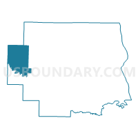
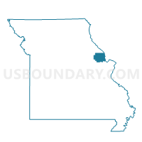
Olney Voting District, Lincoln County, Missouri
About
Outline

Summary
| Unique Area Identifier | 608978 |
| Name | Olney Voting District |
| County | Lincoln County |
| State | Missouri |
| Area (square miles) | 36.98 |
| Land Area (square miles) | 36.74 |
| Water Area (square miles) | 0.25 |
| % of Land Area | 99.34 |
| % of Water Area | 0.66 |
| Latitude of the Internal Point | 39.08779130 |
| Longtitude of the Internal Point | -91.21177300 |
Maps

Graphs
Select a template below for downloading or customizing gragh for Olney Voting District, Lincoln County, Missouri


Neighbors
Neighoring Voting District (by Name) Neighboring Voting District on the Map
- Ashley NO/Hartford PQ Voting District, Pike County, MO
- Bellflower Voting District, Montgomery County, MO
- Hawk Point Voting District, Lincoln County, MO
- Louisville Voting District, Lincoln County, MO
- Middletown Voting District, Montgomery County, MO
- Millwood Voting District, Lincoln County, MO
- Truxton Voting District, Lincoln County, MO
Top 10 Neighboring County Subdivision (by Population) Neighboring County Subdivision on the Map
- Hawk Point township, Lincoln County, MO (2,472)
- Millwood township, Lincoln County, MO (918)
- Prairie township, Montgomery County, MO (882)
- Hartford township, Pike County, MO (533)
- Waverly township, Lincoln County, MO (412)
- Prairie township, Lincoln County, MO (380)
- Nineveh township, Lincoln County, MO (346)
Top 10 Neighboring Unified School District (by Population) Neighboring Unified School District on the Map
- Troy R-III School District, MO (33,238)
- Bowling Green R-I School District, MO (11,119)
- Wellsville-Middletown R-I School District, MO (2,629)
- Silex R-I School District, MO (2,565)
Top 10 Neighboring State Legislative District Lower Chamber (by Population) Neighboring State Legislative District Lower Chamber on the Map
- State House District 11, MO (48,326)
- State House District 99, MO (42,788)
- State House District 10, MO (35,091)
Top 10 Neighboring State Legislative District Upper Chamber (by Population) Neighboring State Legislative District Upper Chamber on the Map
- State Senate District 2, MO (242,885)
- State Senate District 16, MO (188,295)
- State Senate District 18, MO (159,547)
Top 10 Neighboring 111th Congressional District (by Population) Neighboring 111th Congressional District on the Map
Top 10 Neighboring Census Tract (by Population) Neighboring Census Tract on the Map
- Census Tract 4603, Pike County, MO (5,984)
- Census Tract 8102.02, Lincoln County, MO (5,805)
- Census Tract 9701, Montgomery County, MO (2,624)
Top 10 Neighboring 5-Digit ZIP Code Tabulation Area (by Population) Neighboring 5-Digit ZIP Code Tabulation Area on the Map
- 63377, MO (2,462)
- 63349, MO (1,934)
- 63359, MO (1,296)
- 63333, MO (783)
- 63381, MO (532)
- 63370, MO (33)